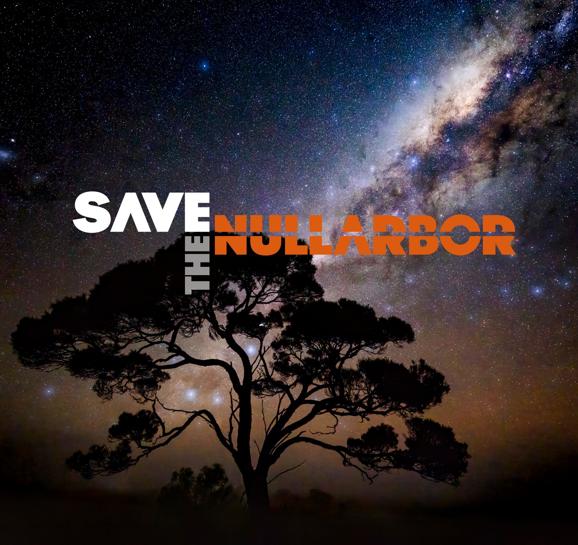
Gargantuan Hydrogen hub ignores Nullarbor World Heritage values
Australia’s largest limestone cave system is under threat from a colossal renewables-powered hydrogen / ammonia production and export project. If it goes ahead, the proposed development will impact more than 22,000 square kilometres of fragile limestone landscape, caves, Aboriginal cultural heritage, underground ecosystems and connected marine ecosystems, despite the area’s proven World Heritage values.
The giant 70 GW pa export energy hub, almost one-third the land area of Tasmania, is planned by a consortium of foreign corporations touting equity partnership with Native Title holders. The foreign consortium proposes to produce hydrogen / ammonia predominantly for export to Korea.
The so-called Western ‘Green’ Energy Hub was referred to the EPA in Western Australia in November 2024, with a restrictive seven-day initial public comment period, during which a remarkable 282 public submissions were received, with the vast majority 92% demanding the most stringent level of environmental assessment within that state 1.
Most recently, on 23rd January 2025, the proposed development has been referred to the Commonwealth Department of Environment and Water for assessment under the Environmental Protection and Biodiversity Conservation Act (EPBC Act) as to whether the project is a 'controlled action' that needs to be assessed by the Minister 2.
Nullarbor scientists and an environmental law and policy expert are again calling on the Australian Government to save the iconic region amid growing concern over the destruction of the environment to make way for large-scale renewables projects in nature hotspot areas with recognised outstanding universal values 3, 4.
In 1992 a report commissioned by the Commonwealth Government of Australia determined that the Nullarbor karst meets four World Heritage integrity criteria based solely on natural heritage values, even before considering cultural heritage or marine ecosystem values5. Only one criterion is needed for World Heritage listing.
In an ironic twist, the proposal to industrialise the West Australian side of the Nullarbor is being supported by the West Australian state government while at the same time the South Australian state government continues to support its 2022 election commitment to secure World Heritage protection for the South Australian side of the Nullarbor and Great Australian Bight, which recent studies have established meets an exceptional seven criteria for nomination6. Only two other places in the world meet seven World Heritage criteria - Southwest Tasmania, and Mount Taishan (China).
Both the South Australian and Western Australian sides of the Nullarbor share outstanding universal values of proven World Heritage quality5,6.
To allow the energy hub proposal to proceed on the Western Australian side of the Nullarbor while the South Australian side is nominated for World Heritage contradicts Australia’s legal obligations under the UNESCO Convention.
Dr Gerry Bates, Specialist in Environmental Law and Policy said:
“Australia, as a signatory to the UNESCO Convention concerning the protection of cultural and natural heritage, has a legal obligation to identify and protect areas of outstanding universal value.”
“The entire Nullarbor Plain, a unique arid karst region of the World, has already been identified as potentially having multiple outstanding universal values, according to a report submitted to the Commonwealth in 1992.”
“The Minister for the Environment may immediately declare a property that is likely to have world heritage values as a 'declared world heritage property' under s 14 of the Environment Protection and Biodiversity Conservation Act 1999, which would trigger protective functions under the Act, including the necessity for the environment minister to assess the proposal for significant impacts on world heritage values.” “The Australian Government needs to step in and make such a declaration, just as it did to save the Franklin River in 1982 and later the Queensland Wet Tropics.”
Professor David Gillieson, expert cave scientist and former Vice-President of the Australasian Cave and Karst Management Association said:
“As part of the caving and scientific community in Australia, we are appalled to hear that the Western Australian government might permit the destruction of the world’s largest arid limestone karst system.”
“The Nullarbor caves have preserved ancient underground landscapes, environmental histories and endemic fauna that have remained ‘frozen in time’ for hundreds of thousands and even millions of years. ”
“Internationally well-recognised cave and karst scientists have questioned why Australia has not yet proceeded with a World Heritage nomination for the whole of the Nullarbor Plain.” “We urgently call on the Australian Federal Government to halt assessment of the proposed WGEH energy development until an independent and thorough assessment has been made of the entire Nullarbor region’s National and World Heritage values.”
Dr Stefan Eberhard, cave scientist and co-founder of Save the Nullarbor Inc.
has been exploring and studying the Nullarbor’s caves for more than 40 years said:
“The Nullarbor Plain is a nature hotspot with outstanding universal values. It is the world’s largest arid limestone karst system, which includes a spectacular hidden world of ancient caves and rock holes of staggering dimensions, beauty, scientific values, rare species and priceless cultural importance.”
“A comprehensive reappraisal of the entire Nullarbor limestone region is now long overdue.”
“The need for an independent assessment is urgent given the imminent threat of this colossal industrial development proposed on the West Australian side, while in stark contrast, the South Australian side is being promoted for World Heritage status.” “If this development is allowed to go ahead in Western Australia the risks of significant impacts to caves, landforms and cultural heritage situated in the adjoining Nullarbor National Park-Wilderness Protection Area, and the Great Australian Bight marine parks, will be unacceptably higher due to a massive increase in the local permanent population, from currently less than 100 at Eucla and Border Village, to approximately 8,000 in a proposed new town constructed for the energy hub3.”
“Irrespective of even the most strident commitments to impact avoidance, mitigation and rehabilitation, and even if such measures are made legally enforceable under EPA and EPBC Act Conditions of Approval, the proposed WGEH energy development would wreak unavoidable harm - environmental, cultural and social – not only within the proposed development footprint, but very importantly, across the entire Nullarbor region and Great Australian Bight.”
“Hundreds of ancient caves and rockholes, and thousands of blowholes and sink holes situated inside, and outside, the proposed industrial footprint will be placed at significant risk if this development is permitted to go ahead. The sheer number of sensitive and important caves, karst landforms, and cultural sites means it will be impossible to avoid or mitigate impacts on all of them.
“In addition to the caves and rock holes, the overall integrity, environmental health, and natural intactness, of the landscape will be seriously compromised because it will involve permanent and partial clearing of vegetation across hundreds of square kilometres of fragile limestone Country. There would be thousands of kilometres of roads, power lines, and underground pipelines which will damage and erode the fragile soil, and potentially change the hydrology, sediment, and energy inputs into the underground ecosystem which is the home of rare, endemic and unique cave species."
Dr. George Veni, Executive Director, National Cave and Karst Research Institute USA (2007-2023) and President, International Union of Speleology (2013-2022) said:
“The Nullarbor Karst Plain is unique and important for many reasons. It is among the most famous karst areas of the world.”
“The Nullarbor Karst Plain is too important and vulnerable an area to risk adverse impacts. It deserves the highest level of protection and ideally should be listed as a World Heritage Site."
“The Nullarbor Karst Plain is too important and vulnerable an area to risk adverse impacts. It deserves the highest level of protection and ideally should be listed as a World Heritage Site."
Professor Nadja Zupan Hajna, President International Union of Speleology (2024) said:
“The ecological diversity and geological formations of the Nullarbor region have attracted the attention of the scientific community worldwide, making it a potential candidate for inscription on the World Heritage List.”
Professor Tadej Slabe, Head of the Karst Research Institute of the Research Centre of the Slovenian Academy of Sciences and Arts said:
“The proposed project poses significant risks to this iconic landscape, including habitat destruction, soil erosion, disruption of ecological processes and harm to cave dwelling fauna and flora.”
“We call on the Australian Federal Government to thoroughly review the proposed WGEH project to protect the values of the Nullarbor as a potential World Heritage Site.”
“We call on the Australian Federal Government to thoroughly review the proposed WGEH project to protect the values of the Nullarbor as a potential World Heritage Site.”
Additional Facts.
The Nullarbor stretches across the lower part of Western Australia and South Australia and connects with the coastal and marine ecosystems of the Great Australian Bight (see map later below).
In 1992 a report commissioned by the Commonwealth Government of Australia determined that the Nullarbor karst meets four World Heritage integrity criteria based solely on natural heritage values, even before considering cultural heritage or marine ecosystem values1. Only one World Heritage integrity criterion needs to be met for a place to be nominated for listing. The bid for World Heritage nomination was not supported by the Western Australian Government at the time.
Subsequently, a substantial portion of the karst on the South Australian side was protected within the Nullarbor National Park and Wilderness Protection Area, the Nullarbor Regional Reserve, and the Far West Marine Park / Great Australian Bight Marine Park.
In November 2022 the Wilderness Society and Sea Shepherd Australia published a consultation document substantiating the case for World Heritage nomination of the network of existing reserved lands, sea and islands lying within the South Australian side of the Nullarbor and Great Australian Bight4. This report identified that:
“The Nullarbor and Great Australian Bight satisfy seven of the 10 criteria for Outstanding Universal Value, making the area one of the most diverse and valuable heritage properties in the world. Currently, there are only two properties on the World Heritage List that meet seven criteria – the Tasmanian Wilderness (Australia) and Mount Taishan (China). Satisfying seven World Heritage criteria makes the Nullarbor and Bight a truly extraordinary candidate for inscription on the List”.
References cited.
1. https://www.epa.wa.gov.au/proposals/western-green-energy-hub2. https://epbcpublicportal.environment.gov.au/all-notices/project-decision/?id=5473a3f4-27d9-ef11-8eea-002248978a7f3. Middap, C. (2024) Weekend Australian newspaper, November 2-3, 2024, P1,2, ‘Out of control’: scientists plead over wind and solar farm destruction.4. Middap, C. (2024) Weekend Australian newspaper, November 16-17, 2024, ‘Like dropping a brick on a meringue’. P1,7, 5. AG Davey, M R Gray, K G Grimes, E Hamilton-Smith, J M James & A P Spate (1992) WORLD HERITAGE significance of karst and other landforms in the NULLARBOR region, A report to the Commonwealth Department of The Arts, Sport, The Environment & Territories, pp202. https://catalogue.nla.gov.au/catalog/13753296. https://www.wilderness.org.au/images/uploads/WorldHeritageBightNullarbor.pdf
END TEXT - MAPS & PHOTOS FOLLOW
Media Support:
To find out more about the Nullarbor limestone karst and its superlative natural and scientific values visit:
https://linktr.ee/savethenullarborwww.savethenullarbor.org
Maps and 12 photos following are available as unmarked jpeg files, source and photographers to be credited.
Media Contacts:
Stefan Eberhard
Bronwen Eberhard
Email: admin@savethenullarbor.org

File Name: MAP-1_Nullarbor Region & Tenure_11Nov24. Source: Save The Nullarbor Inc.
Onshore portion of the Eucla Basin showing the extent of Nullarbor limestones (bright yellow and green) which coincide with the Nullarbor and Hampton biogeographic regions (IBRA). Also shown are reserves, marine parks, pastoral leases, settlements, transcontinental railway, and State border. The proposed 22,000 km2 Western Green Energy Hub footprint (red shading) sits atop the central portion of the karst which contains a notably high density of recorded karst features including many highly important and sensitive caves.
Note the proximity of the proposed industrial hub to the Nullarbor National Park-Wilderness Protection Area, and the Great Australian Bight marine parks in South Australia, which are proposed for World Heritage nomination.
The high density of recorded features in the central portion of the karst coincides with concentrated and systematic exploration efforts by speleologists in recent decades (= sampling bias) and thus the apparent lower density of features west, east, and north of the proposed WGEH footprint almost certainly under-represents the true density of features across the Nullarbor.
One conclusion to draw from this map is that large-scale wind and solar industrial developments proposed anywhere on the Nullarbor limestones (bright yellow and green) will almost certainly intersect with, and impact upon, a significantly greater number of karst features than is currently known and recorded.

File Name: MAP-2_Nullarbor Caves & WGEH_11Nov24. Source: Save The Nullarbor Inc.
Inside the proposed Western Green Energy Hub development footprint, more than 4,500 karst features have been recorded, including >400 caves, >500 rock holes, >1,900 blowholes, > 1,470 dolines (sink holes).
Note the occurrence of Recognised Aboriginal Heritage Places inside the proposed footprint and adjacent areas, however there are many more sites of cultural heritage signifcance which have not been formally recognised.
The blank areas on the map do not mean there are no caves or karst features present, only that cavers and speleologists have not yet searched these areas.
More than 70 years of systematic exploration and research by cavers and speleologists have documented more than 13,000 karst features and mapped more than 150 kilometres of cave passage to date, however, this is just a fraction of what lies undiscovered beneath the surface of the Nullarbor.
More than 70 years of systematic exploration and research by cavers and speleologists have documented more than 13,000 karst features and mapped more than 150 kilometres of cave passage to date, however, this is just a fraction of what lies undiscovered beneath the surface of the Nullarbor.
.jpg)
File Name: Nullarbor-1. Photo Stefan & Bronwen Eberhard.
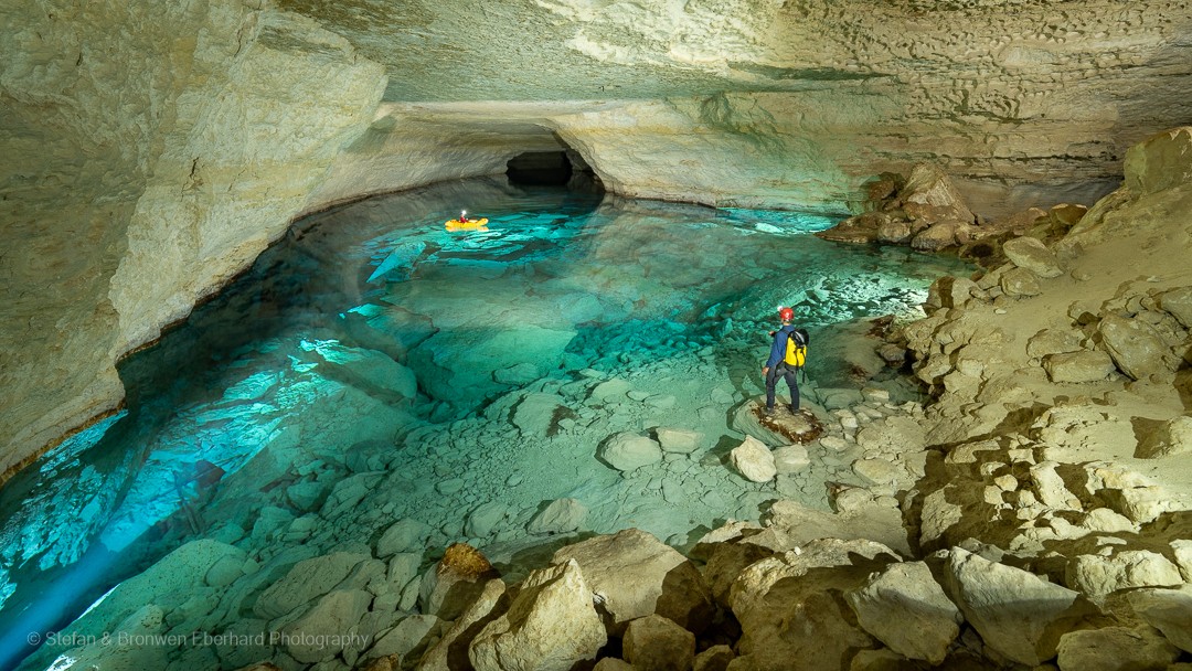
This huge cavern is but a short segment of an enormous underground drainage system which carries ancient groundwater hundreds of kilometers from the northern edge of the limestone plain to the Southern Ocean. The proposed energy hub lies only a few kilometers away and within the upstream catchment area of this extraordinary cave system of undoubted World Heritage significance. To the west and east of this cave system there are other similar giant underground river systems carrying groundwater through the Nullarbor limestone aquifer. With a surface area of around 200,000 square kilometers, the Nullarbor Plain indisputably harbors one of the greatest cave and karst systems on Earth.
If the Western Green Energy Hub is allowed to go ahead the risks of inadvertent or deliberate damage to this magnificent cave will be exponentially higher due to a massive increase in the local permanent population, from currently less than 100 at Eucla and Border Village, to approximately 8,000 in a proposed nearby energy hub village.
This cave is a very important roost site for a large population of cave dwelling bats; and the bat guano supports a rich invertebrate fauna living on the floor of the cave. Both the bats and invertebrates are susceptible to disturbance by human visitors.
.jpg)
File Name: Nullarbor-2. Photo Bronwen Eberhard.
The Nullarbor Plain is famous for its giant dolines or ‘sinkholes’ which are formed by collapse of the limestone into enormous, flooded cave conduits which snake their way through the aquifer which lies ~ 90 meters below the surface. The collapse dolines, which are few and far between, are small windows into segments of the enormous underground river systems which carry ancient groundwater hundreds of kilometers through the limestone aquifer to the Southern Ocean. This doline is 40 meters in diameter, note the vehicle for scale lower right. The integrity and unspoiled intactness of this fragile limestone landscape and world-class cave system is threatened by the proposed Western ‘Green’ Energy Hub.
File Name: Nullarbor-3. Photo Stefan & Bronwen Eberhard.
This stunningly beautiful cave of undoubted World Heritage quality lies only a few kilometres away from the proposed colossal hydrogen / ammonia production plant and storage facility.
If the Western Green Energy Hub is allowed to go ahead the risks of inadvertent or deliberate damage to this magnificent cave will be exponentially higher due to a massive increase in the local permanent population, from currently less than 100 at Eucla and Border Village, to approximately 8,000 in a proposed nearby energy hub village.
This cave is a very important roost site for a large population of cave dwelling bats; and the bat guano supports a rich invertebrate fauna living on the floor of the cave. Both the bats and invertebrates are susceptible to disturbance by human visitors. This cave is the habitat for several rare blind cave species including beetles, centipedes, spiders, cockroaches and crustaceans. The cave lake and its submerged tunnels are the habitat of extraordinary microbial communities which occur nowhere else on Earth.
Beneath the surface of the Nullarbor Plain there is a vast, salty, limestone aquifer which drains into the Southern Ocean through an immense and intricate cave system which carry crystal-clear groundwater hundreds of kilometres from the northern inland margin of the limestone plateau all the way to the coastline where it discharges into the ocean in the Great Australian Bight.
The beautiful cave lake in this photograph is a rare window into a 400m long segment of this immense cave drainage system, offering a tiny glimpse into a world otherwise completely hidden from view ~ 90 meters beneath the surface of the Plain. Because of the highly porous and cavernous nature of the Nullarbor limestones, the Nullarbor aquifer and its unique life forms are highly vulnerable to contamination.

File Name: Nullarbor-4. Photo Stefan Eberhard.
For more than 50 years cave divers have been exploring and mapping the stunningly beautiful and internationally famous underwater caves of the Nullarbor. This world-class cave lies only a few kilometres away from the proposed colossal hydrogen / ammonia production plant and storage facility.
The Nullarbor aquifer and caves are the habitat of extraordinary life forms including troglobites, stygofauna and rare underwater microbial communities, which occur nowhere else on Earth. This cave supports the largest and most spectacular examples of underwater microbial colonies up to 50cm in length.
This tunnel has been explored by cave divers for around 400 metres distance and 40 metres water depth to a point where further exploration is blocked by boulders however the cave system continues beyond, carrying ancient groundwater hundreds of kilometres from the inland margin of the limestone plateau all the way to the coastline where it discharges into the ocean in the Great Australian Bight.

File Name: Nullarbor-5. Photo Peter Rogers.
The cave lakes and underwater tunnels on the Nullarbor support rare and unique extremophile organisms known as microbial mantles, a highly unusual and specialized community of primitive bacteria and archaea of great scientific interest. Similar types of organisms are found in volcanic hot springs and deep ocean vents; however, the Nullarbor community represents a distinctive microbial ecosystem. These soft gelatinous tentacles, which can grow up to 50 cm in length, are extremely fragile and vulnerable to any kind of disturbance or groundwater contamination. This community lies only a few kilometres away from the proposed colossal hydrogen / ammonia production plant and storage facility.

File Name: Nullarbor-6. Photo Paul Devine.
The largest, rarest, and most unusual Nullarbor troglobite is a blind spider, Troglodiplura, which is of considerable scientific interest because it is the only known cave-adapted example of its ‘family’ in Australia and one of only a few such cave-adapted mygalomorphs worldwide. Recent research has found that these spiders are able to migrate tens of kilometers underground in complete darkness between caves using the vast interconnected network of small micro-caves which honeycomb the entire Nullarbor Plain. Troglodiplura is the Australian Cave Animal of the Year 2024.
.jpg)
File Name: Nullarbor-7. Photo Stefan & Bronwen Eberhard.
The Nullarbor is a living cultural landscape of priceless importance. Mirning People are the Traditional Custodians of the Nullarbor limestone Country.
These ochre hand stencils in a Nullarbor cave convey a powerful and poignant story of Mirning Peoples co-existence with Nullarbor karst Country spanning at least 40,000 years, or 2,000 generations. Hundreds, if not thousands, of caves, rock holes and other potential cultural heritage sites may be threatened if the Nullarbor is transformed into an enormous 22,000 square kilometers industrial wind and solar farm to produce hydrogen / ammonia for export overseas.
Nullarbor caves were used by Mirning People for shelter, ceremony, and creative expression, as well as a source of water and flint for stone tools. Additional to caves, there is a multitude of other evidence that record Mirning Peoples links with Nullarbor Country, including rock holes with cap stones, artefact scatters, stone manuports and intriguing stone arrangements. These all point to the strong and enduring connection that the Mirning Peoples had, and which the living descendants of Mirning Peoples continue to have, with Nullarbor karst Country and connected Sea Country.
File Name: Nullarbor-8. Photo Stefan Eberhard.
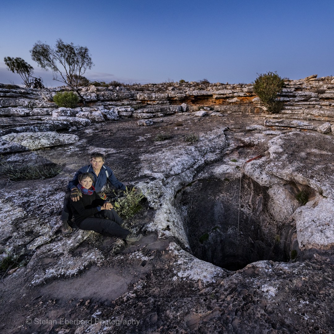
Stefan & Bronwen Eberhard, co-founders of Save The Nullarbor Inc. Cave scientist, cave diver and photographer Dr Stefan Eberhard has been exploring, researching and photographing the Nullarbor caves over 42 years. In 2023 Stefan and his wife Bronwen spent nine weeks camping on the Nullarbor to photograph and film the natural beauty of this threatened, globally unique, arid limestone karst region.

File Name: Nullarbor-9. Photo Stefan Eberhard.
This wild spectacular and unspoiled view of the Yinyila sand dunes and the Southern Ocean from Eucla is well-known to travellers and tourists driving across the Nullarbor Plain. Yinyila is also a place of great cultural significance to the Yerkala Mirning People. If the proposed hydrogen hub is allowed to go ahead this unspoiled vista will be forever marred by a large desalination plant and shipping port ~ 20 km west of this popular lookout, where hydrogen / ammonia will be piped to large tanker ships for export to Korea.

File Name: Nullarbor-10. Photo Stefan Eberhard.
This gaping cave entrance ~ 60m across at its widest point leads into an enormous tunnel which slopes downwards to meet the aquifer ~ 90m below the surface, and from there the tunnel continues completely submerged, the realm of cave divers and rare microbial life forms.
If the Western Green Energy Hub is allowed to go ahead the risks of inadvertent or deliberate damage to this magnificent cave will be exponentially higher due to a massive increase in the local permanent population, from currently less than 100 at Eucla and Border Village, to approximately 8,000 in a proposed nearby energy hub village.
This cave is a unique window into a short segment of a vast underground river system carrying ancient groundwater hundreds of kilometres from the inland limestone margin to the Southern Ocean. This cave system of World Heritage quality is only a few kilometers away from the colossal hydrogen / ammonia production plant and storage facility which is proposed to be in the visible distance in this photograph.
This cave is a very important roost site for a large population of cave dwelling bats; and the bat guano supports a rich invertebrate fauna living on the floor of the cave. Both the bats and invertebrates are susceptible to disturbance by human visitors.

File Name: Nullarbor-11. Photo Stefan & Bronwen Eberhard.
This spectacular cave of exceptional natural heritage significance lies only a few kilometres away from the proposed colossal hydrogen / ammonia production plant and storage facility.
If the Western Green Energy Hub is allowed to go ahead the risks of inadvertent or deliberate damage to this magnificent cave will be exponentially higher due to a massive increase in the local permanent population, from currently less than 100 at Eucla and Border Village, to approximately 8,000 in a proposed nearby energy hub village.
This cave is a very important roost site for a large population of cave dwelling bats; and the bat guano supports a rich invertebrate fauna living on the floor of the cave. Both the bats and invertebrates are susceptible to disturbance by human visitors. This typical large Nullarbor cave passage has been formed by a gradual upwards collapse of the roof over millions of years. Deeper beneath the rock-strewn floor lies the aquifer and a large waterfilled conduit which has been gradually dissolving the soluble carbonate limestone and carrying it away in solution, thus enabling the cave to grow larger over time.

File Name: Nullarbor-12. Photo Stefan Eberhard.
There is more to the Nullarbor (Latin: meaning “no trees”) than meets the eye. Beneath the surface lies an incredible hidden world of caves, of staggering beauty and scientific value.
This cave is in the heartland of Nullarbor karst Country, inside the proposed footprint of the colossal wind and solar hydrogen hub.
Explored and mapped by cavers, to date, it has a surveyed length of 37 kilometres, and this impressive extent of cave passage is contained within just a few square kilometres of limestone plain. With a surface area of around 200,000 square kilometres, the Nullarbor Plain indisputably harbours one of the greatest cave and karst systems on Earth.
The Nullarbor remains a kind of wilderness, where it is possible to experience raw and pure nature, profound stillness, immense space with uninterrupted horizon views, and the most brilliant starry night skies imaginable.
Large intact and relatively pristine regions such as the Nullarbor are becoming rarer.